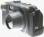
 PRESS RELEASE: Ricoh Optimizes 500SE GPS-Enabled Digital Camera
New features provide improved GPS and data-collection capabilities
San Diego, CA (PRWEB) July 13, 2009 -- Ricoh America's Corporation, a leading provider of digital office equipment and business solution cameras, today announced at the ESRI User Conference in San Diego the release of major hardware and firmware enhancements to its 500SE GPS-ready camera.
To provide the best solution for GIS workflows that require quality images, Ricoh has announced the new SE-2 GPS module line for the 500SE to provide superior GPS reception, capabilities and accuracy. The SE-2 modules, designed by EKA Technologies, Inc, incorporates state-of-the-are GPS components into a small, power-efficient, and ruggedized housing that attaches to the side of the 500SE, providing an all-in-one geo-imaging solution.
"The SE-2 represents Ricoh's commitment to provide cutting-edge technology to its customers," said Jeff Lengyel, national manager for Ricoh's Camera Division. 'Unlike other GPS cameras and imaging devices with built-in GPS, the 500SE was designed with a modular approach to ensure the camera's capabilities follows the rapid technology curve in the GPS industry.'
The new modules are available in two versions. The SE-2g provides GPS capability while the SE-2c offers GPS and a 3-axis compass for direction (azimuth) information. Key advantages of the SE-2 modules are its small form-factor, significant power saving capabilities and faster GPS fix times, due to it new helix antenna. The SE-2c and SE-2g are also less expensive then previous modules with a MSRP of $169.00 and $399.00 respectively.
To further enhance the camera's data-collection capabilities, Ricoh has also announced a new firmware release for the 500SE that allows it to collect up to ten attributes of field data via an easy-to-use on-board data dictionary or by utilizing the camera's barcode scanning capabilities. Additionally, an unlimited number of data dictionaries may be stored on the camera to provide a virtually unlimited amount of data to embed into images as they are captured. This image 'meta-data' becomes attribute data in GIS mapping applications. The new firmware also allows up to three attributes as well as GPS position, azimuth and UTC (satellite time) to be imprinted directly onto images as they are captured
Information about Ricoh's complete range of products and services may be accessed on www.ricoh-usa.com. Information on the 500SE may be accessed at www.ricoh-usa.com/geo.
About Ricoh Americas Corporation
Ricoh Americas Corporation, headquartered in West Caldwell, N.J., is a subsidiary of Ricoh Company Ltd., the 73-year-old leading supplier of office automation equipment and electronics, with fiscal year 2008 sales in excess of $20 billion.
Ricoh Americas Corporation is a leading provider of document solutions and business solution cameras. Ricoh's fully integrated hardware and software products help businesses share information efficiently and effectively by enabling customers to control the input, management and output of documents. Ricoh's Digital Camera Division manufactures and services innovative, quality cameras that demonstrate industry-leading performance capabilities.
Ricoh Americas Corporation directly or through its network of authorized dealers markets and distributes products in North, Central and South America.
Information about Ricoh's complete range of products and services can be accessed on the World Wide Web at www.ricoh-usa.com.
###
(First posted on Monday, July 13, 2009 at 12:54 EDT)